Duration:
2.5 hours, 6km
Difficulty:
6/10. Not very difficult but parts are overgrown and the thorny leaves and branches are really annoying
Cel phone coverage: Everywhere
Water needs: 1 liter
Appreciation: 7/10 after very large rainfall. I would think that it is very unimpressive when it hasn't rained
Transportation:
HKU Station Exit A1. Return via bus on The Peak
Why it's worth it:
--------------------------
 |
| Take the MTR to HKU. Exit A1, HKU FB level. |
 |
| When out of the elevator, just go straight and cross the University grounds. |
 |
| Behind the University, you'll see University Avenue. Take the stairs down to reach it, then head right. |
 |
| Up the little hill... |
 |
| The stairs to take will be on your left, right after the Chow Yei Ching Building. |
 |
| Climb the stairs all the way to the top. Head right atop the stairs. |
 |
| There will be many paths to your left. None to be taken. Keep going on the main path. |
 |
| Similarly, many streams which may seem inviting... stay the course! |
 |
| The first stream is about 1.4km from your starting point. |
 |
It is not too hard to find as there will be a flight of stairs on your right just before it.
Don't rely on the green boards being there. The stream actually has a well defined path following it.
|
 |
| Very pwehtty when there it has been raining a lot. |
 |
| At one point, you'll reach a larger waterfall and the stream branches to the right as well, with the path following it. You will want to climb a few steps on the right, then take the path leading left to the top of the waterfall and to the left-stream. |
 |
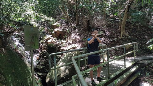
| From the entrance of the stream to the exit (pictured above), it should take you about 20-30 minutes. Head right. In about 800m (12-15min), you will connect with Hong Kong trail section 1 |
 |
| Keep going on HK trail section 1 |
 |
| Don't take stairs going down. HK trail section 1 I said! |
 |
| About 3km and 1 hour walk from the exit of the first stream, you'll reach the entry point of the second stream. It might be easier to miss but one sure indicator that you missed it is if you get to the sharp turn in the trail |
 |
| The second stream's entrance. One helpful indicator is the CW-28 sign on the left. Not sure whether that will stay there forever though... |
 |
| This second stream is about 700m long from entrance to exit. Try to stay in the stream as much as possible as the thorny bushes on the edge of the stream are, at best, annoying. Also, stick to the stream with most water, when encountering a fork. In all cases, it will more or less get to the same spot. But it will be easier and nicer in a larger stream |
 |
| You'll eventually reach that bridge on Harlech Road. You'll get some mesmerized glances from people walking by. Go under the bridge and climb the fence on the left. That's it! Head right on Harlech and you will be at The Peak in about 1 minute. |


